Posted on: June 08, 2026
From a hydrology standpoint, metro Atlanta entered May like a football team down by four touchdowns.
Over the previous 12 months, the region only received 35.5 inches of rain – about 14 inches below normal. Lake Lanier, our largest source of drinking water, was more than 5 feet below “full pool.” And in late April, Georgia EPD declared a Level 1 drought all of metro Atlanta.
When the skies finally opened in May, dumping an average of 5.3 inches of rain (and much more in some areas), many wondered if our water worries were behind us. Unfortunately, that’s not the case. Here are three reasons why:
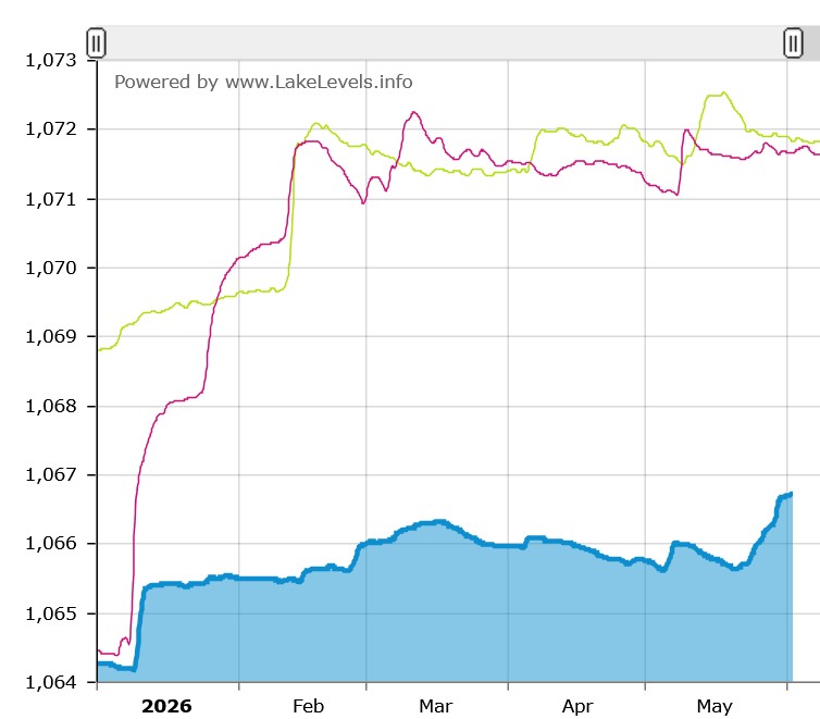
Lake Lanier remains low
Despite all the rain, Lake Lanier remains about four feet below full pool. We’ll need quite a bit more rain to bridge that gap. Look for strong summer storms, perhaps even remnants of a hurricane, to fill the need.
For context, the lake is about four feet lower today than it was at the same time in 2025 and 2024, as the chart below illustrates:
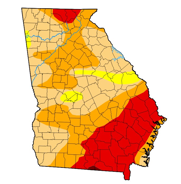
Drought conditions still exist
But according to the official U.S. Drought Monitor map, most of our region remains in “severe drought” conditions, as the map below shows.
How can that be? The soaking rains certainly helped, but remember, we have been extraordinarily dry, and it takes a LOT of rain to fundamentally change conditions.
Many variables are used to develop the drought map, including precipitation, stream flow, reservoir levels, temperature, soil moisture, and vegetation health.
Uncertain outlook ahead
A recent report from NOAA says drought conditions will remain in June, though things will improve during the month.
Looking further out, forecasters are expecting a quieter hurricane season this summer and fall, thanks in part to a strong “El Nino” – a warming of the central Pacific Ocean. This reduces the likelihood of a tropical storm hitting our region and filling our reservoirs.
Water Conservation is Key
The Metro North Georgia Water Planning District, which is managed by ARC, encourages residents to take steps to conserve water as summer approaches.
- Follow state law and water only before 10 a.m. and after 4 p.m. This reduces water loss due to evaporation.
- Choose native plants, espeically those that are drought tolerant
- Check for water leaks at your home and fix them immediately
- Be sure your irrigation system is watering your lawn and garden and not the sidewalk or driveway
More tips can be found at MyDropCounts.org