Atlanta — May 29, 2024
The Atlanta Regional Commission (ARC), Clayton County, and the cities of College Park, East Point, and Hapeville have received an additional $14.9 million grant from the U.S. Department of Transportation to further develop the Flint River Gateway Trails, a planned 31-mile trail network in South Metro Atlanta.
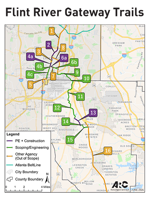
The Flint River Gateway Trails network will connect the Atlanta BeltLine in Southwest Atlanta to Clayton County, passing through the “Tri-Cities” area of College Park, East Point, and Hapeville, which includes the headwaters of the Flint River.
The $14.9 million in federal funds augments a $50 million grant the U.S. DOT awarded to ARC and the four communities in March, bringing the total federal investment to $64.9 million. The federal funds will be used for:
- Scoping and engineering to prepare 16 miles of multi-use trail for construction, in eight segments.
- Construction of 3.2 miles of multi-use trails, in four sections.
- Exploring connectivity of the Flint River Trails network with other trails being discussed in the South Metro area, potentially creating an even larger trails network, with the Flint River as major focal point.
- Providing technical assistance to help local governments manage and oversee the planning and construction process.
- Facilitating ongoing community engagement.
- Incorporating “green construction” elements to manage stormwater runoff and flooding.
“The Flint River Gateway Trails network is a game-changer that will boost quality of life and economic opportunities for South Metro Atlanta communities,” said ARC Chair Andre Dickens, who also serves as Mayor of the City of Atlanta. “The trails network also fills a major gap in our regional trails vision by connecting the Atlanta BeltLine to the Tri-Cities area and through Clayton County.”
The visioning process for the Flint River Gateway Trails network will begin later this year, an important first step to ensure that public input drives the planning process.
The trail network is part of ARC’s “Reconnecting the Region” initiative, which aims to connect communities that have long been divided by major infrastructure projects like highways, railways, and the airport, to offers greater economic opportunities and improved access to services such as health care.
“These additional funds will help advance a trail vision in Clayton County and the Tri-Cities. We are grateful that the U.S. DOT understands this project’s transformational opportunity for South Metro Atlanta and the entire region,” said Anna Roach, ARC Executive Director & CEO.
The Flint River Gateway Trails network builds upon decades of planning and investments in the communities around Hartsfield-Jackson Atlanta International Airport. Twelve foundational, ARC-funded trail projects and plans, such as the Atlanta Regional Trail Vision, AeroATL Greenways Plan, East Point Multimodal Improvements and Tara Boulevard Pedestrian Safety Improvements serve as a catalyst to reconnect Atlanta’s Southside communities.
The federal grants also serve as a key mechanism to fulfill the vision of Finding the Flint, a community-led effort to restore the Upper Flint River, address stormwater and flooding issues, and reconnect neighborhoods through trails and parks. The Flint River begins near the airport in East Point and flows for 344 miles to the Florida state line.
The Flint River Gateway Trails network has been supported by community partners that include The Conservation Fund, Finding the Flint, American Rivers, Aerotropolis Atlanta Alliance, Atlanta BeltLine, the Georgia Department of Transportation, and MARTA.
###
About ARC:
The Atlanta Regional Commission (ARC) is the official planning agency for the 11-county Atlanta Region, including Cherokee, Clayton, Cobb, DeKalb, Douglas, Fayette, Forsyth, Fulton, Gwinnett, Henry, and Rockdale counties as well as the City of Atlanta and 74 other cities. The Atlanta Regional Commission’s mission is to foster thriving communities for all within the Atlanta region through collaborative, data-informed planning and investments.
Contact Name: Paul Donsky
Contact Phone: 470-626-3869
Contact Email: pdonsky@atlantaregional.org