

Past & Present
How the Past Has Shaped Our Present
Terminus to Today
Understanding our region today requires an understanding of where we’ve been. Specifically, it requires an appreciation of the historical context that shaped the geographic, socioeconomic, and infrastructural landscapes that continue to influence the way we live. Looking at historical maps can help us visualize the structural causes of current issues and gives us an understanding of how past decisions inform our present.
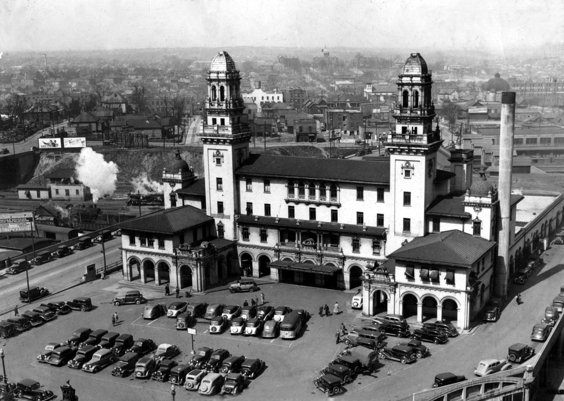
When Terminus, as Atlanta was previously named, emerged, it was not the most populous city in the region. Decatur, founded in 1823, and Marietta, founded in 1834, were already in place by the time Terminus came into being in 1837. Its rapid expansion was due to infrastructure the railroads. As a result, Terminus — which became Marthasville and finally, Atlanta — quickly overshadowed the towns around it.
Old Atlanta
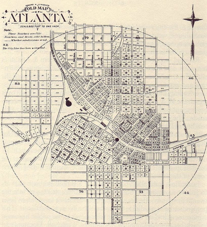
It’s difficult to imagine what Atlanta and the region were like more than 150 years ago, but there are striking similarities linking the city to its pre-Civil War days. This map was produced in 1853 by architect and cartographer Edward A. Vincent, and is one of the oldest street grid maps of the city. While Atlanta has undoubtedly changed in many ways since the mid-19th century, the essential orientation and layout of the downtown grid remain intact.
What the map ultimately reveals is how specific patterns of urban development can persist throughout centuries and continue to influence the growth of a city into the present. The influence of the railroads on Atlanta is particularly apparent as the city’s historic center is a grid, oriented not toward the cardinal points, but instead toward the railroad tracks that gave birth to the city. You can see this clearly as Marietta, Walton, and Luckie streets run perpendicular to the tracks while Spring, Forsyth and Broad streets cross the tracks at ninety degree angles. Atlanta’s streets don’t become oriented to the cardinal directions until Ellis Street, on the southern end of downtown.
Geography of Exclusion
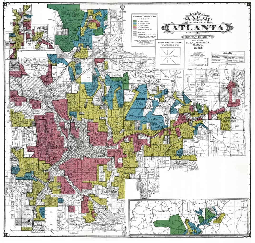
This 1938 Home Owner’s Loan Corporation (HOLC) “Residential Security Map” of Atlanta highlights the geography of redlining. In 1938, as part of an effort to survey the nation’s cities to estimate neighborhood risk levels for long-term real estate investment, the federal government’s HOLC produced this map.
The map and accompanying documents divided the city into 111 residential neighborhoods, assigning each neighborhood a grade, from A to D, which indicated the projected trend of property values in the area, and thus the level of “security” it offered – or the risk it posed – to grantors of home loans.
The “area descriptions” which accompany the map reveal that for the HOLC, property values stemmed from social exclusion: HOLC appraisers awarded a grade of A or B to neighborhoods with high levels of homeownership and racial restrictions on the sale of property, stamped grades of C or D on areas where renters and non-whites resided. The HOLC survey privileged neighborhoods composed exclusively of white homeowners for purposes of property appraisal and loan disbursement.
The vast inequities that exist in today’s Atlanta with respect to treatment by the criminal justice system, as well as access to jobs, housing, education, and healthcare, can only be better understood, and hopefully overcome, by a critical understanding of the neighborhood-based, discriminatory practices of home mortgage lending that are laid out in this HOLC map.
Where We Are Today and Where We Are Headed
A glance out the window is all you need to know the Atlanta region is growing fast. Cranes are busy throwing up the next high rise, businesses are expanding, and moving trucks are frequent sights on the roads.
And according to ARC’s latest long-range forecast, the growth will continue in a big way.
By 2050, we’ll have 2.9 million new neighbors, and a total population of 8.6 million. To put the growth in perspective, it’s as if all of metro Denver will move to the Atlanta region over the next 30 years.
At the same time, the region continues to grapple with longstanding issues of inequality that have left too many residents behind, unable to climb the economic ladder. Issues of racial justice and economic access continue to face metro Atlanta as paramount challenges.
Metro Atlanta to Increase in Diversity
While the headline to the 2050 forecasts understandably is population growth (that 2.9 million figure again), metro Atlanta is more diverse compared to the state of Georgia.
Take a look at the change that’s forecast to occur by 2050:
- The share of white residents will drop to 31%, compared to 44% in 2021.
- The share of Hispanic residents will reach 21%, up from 12% in 2021.
- The share of Black residents will remain fairly steady, at 33% in 2050
compared to 35% in 2021. - The share of residents of “other” race and ethnic backgrounds, a category that includes Asians, will increase to 14%, compared to 9% in 2021.
- Most metro areas are experiencing similar trend lines.
Here in the Atlanta region, consider this: Between 2010 and 2019, metro Atlanta added 81,338 white (non-Hispanic) residents, compared to 351,561 Black residents, 119,713 Asian residents, and 103,753 Hispanic residents.
Region’s Share of Older Adults Set to Rise
As our region is growing much more diverse, its aging population is also growing. In 2021, 5% of people were age 75 or older. That figure is set to reach 12% in 2050, or about 1 million people. And one in three residents will be age 55 or older.
This will have a profound impact on our region, affecting everything from housing and healthcare to transportation.
What’s driving this trend? Think back to the 1990s and 2000s. The Atlanta region was one of the fastest growing regions in the country. Many of the Boomers and Gen-Xers who flocked here back then have stayed, and they will make up the region’s aging population over the next 30 years.
Our aging population is growing substantially, prompting a need to consider how to create communities that work for all stages of life. However, on the whole, compared to areas in the Northeast and Midwest, the region will remain relatively young. More than 2.2 million people will be age 22 or younger in 2050.
Inequity in the Region
Metro Atlanta boasts a great quality of life and thriving economy. But not everyone is sharing in this success.
Too many communities in the Atlanta region face endemic, generational poverty. Income mobility — the ability to move up the economic ladder over a lifetime — remains frustratingly low in these neighborhoods.
The data tell a troubling story
- Wealth Gap: Black households in metro Atlanta make a fraction of what their white counterparts make, with a median income of just $28,105, compared to $83,722 for white households.
- Health Disparities: In metro Atlanta, lifespans differ greatly based on a range of socio-economic factors such as race, housing security, and income. For example, residents in the affluent suburb of Vinings can expect to live to age 87. Less than ten miles away, in Atlanta’s English Avenue neighborhood, life expectancy is 63. Disparities can be found within every county in the region.
- Lack of Upward Mobility: Less than 4% of Atlanta metro residents born into the bottom 20th-percentile of income will make it to the top 20th-percentile in adulthood.
One Great Region
The Atlanta Regional Commission's vision is to create One Great Region - a collaborative vision that seeks to move the region towards a more innovative, world-class, sustainable, and resilient future where everyone has the opportunity to succeed.
In support of this vision, ARC's mission is to foster thriving communities for all within metro Atlanta through collaborative, data-informed planning and investments.
ARC Annual Partners
ARC’s Strategic Partners are committed to fostering collaborative regional approaches that improve quality of life in metro Atlanta. Their support elevates ARC leadership programs, research and events throughout the year. Learn more
Connect
229 Peachtree ST NE, STE 100
Atlanta, GA 30303
Phone: 404.463.3100
Fax: 404.463.3205
About Us
Resources by Type
Resources by Topic
© 2022 Atlanta Regional Commission. All Rights Reserved.


