Montreal
Transportation: ...
The Montreal region faces transportation challenges familiar to anyone visiting from metro Atlanta: a growing population, congested freeways and main arterials, and declining transit ridership in the post-COVID era.
But there are some significant differences. For one, the core of the Montreal region is an island in the mighty St. Lawrence River, which complicates efforts to connect primary job centers and attractions to more outlying areas.
Another distinction: the provincial government, Quebec, provides substantial financial support for transit operations and expansions in Montreal. They’re even footing the bill for a new light rail system, more info on that below.
And then there’s the weather. Montreal’s harsh winter climate requires plenty of preventative upkeep, and snow and ice can grind the region’s transportation network to a halt.
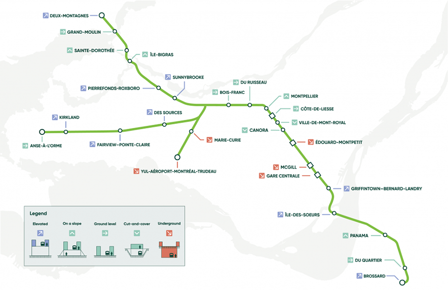
That said, the Montreal region has much going for it from a transportation perspective, from a growing bike-ped system to major transit expansions. An extension of one of the main metro lines is under construction, and the first phase of a planned CA$6.9 billion light rail system, called the Réseau express métropolitain, or REM, opened earlier this summer for service.
Let’s take a deeper dive into the Montreal region’s transportation network, and what’s to come on the horizon.
How Montreal Residents Get Around
To level set, let’s start by taking a look at the primary ways Montreal area residents get to work. Driving leads the way at 69%, but more than one in three residents uses transit, walks, or bikes to work.
That’s according to the latest Canadian Census data, from 2016. Of course, that was before COVID-19, and ridership is about 70% of pre-pandemic levels.
Transit Network
Montreal’s public transit system plays a significant role in the region’s transportation network. It includes:
- Heavy rail: The STM (for Société de Transport de Montréal) operates a four-line rail system, known as the metro that includes 68 stations, all but a few located on the Island of Montreal. To avoid winter weather, the entire system is under ground, with some directly connected to major buildings.

- Bus Rapid Transit: STM operates a bus-rapid transit line on Pie-IX Boulevard, one of the region’s major thoroughfares that cuts across the Island of Montreal to the suburbs in Laval. The line opened last fall with 28 sheltered stops, primarily located in the center of the road. Buses operate in dedicated lanes and have traffic-signal priority at major intersections.
- Bus: STM also operates an extensive bus network that includes more than 200 routes integrated with the rail system. STM is committed to the transition to electrification of its fleet. The system now includes hybrid and fully electric vehicles, and STM boasts that more than 84% of trips are now electric.
- Commuter rail & regional bus: Exo operates commuter rail and regional bus service across the Montreal region. The network includes six train lines, 237 bus routes, and 52 taxibus routes, a rideshare service.
- Light rail: The first section of the CA$6.9B Réseau Express Métropolitain (REM) light rail line opened July 28, 2023. When built out, the 67-kilomter system will be nearly as big as the heavy rail metro system, with 26 stations linking downtown, the airport and the Greater Montreal
- ARTM Unified Fare System: The region has also been investing in a major effort to provide a unified fare system. The system is managed by the Autorité Régionale de Transport Métropolitain, or ARTM, which was established in 2017 to create a more seamless, better integrated, and more efficient transit network to simplify access for users.
Roads & Highways
The most important thing to keep in mind when talking about Montreal’s roads and highways is geography. The region’s core is the Island of Montreal, which is surrounded by the St. Lawrence River.
A good deal of the Montreal region consists of “off-island” suburbs. The sizable width of the St. Lawrence River has made it difficult to connect these areas to the region’s core, especially communities located to the south in what’s known as the South Shore.
Grid-like Highway System
The region is crisscrossed by highways in a grid-like pattern, including six that are part also of the Trans-Canada highway system.
Quebec Autoroute 40 forms the region’s spine, traversing the center of the Island of Montreal roughly perpendicular to the river. Several highways cross the island, connecting suburban communities on the North Shore and South Shore to the island.
The South Shore, where the river is widest, is connected to the island by just four road bridges, one road tunnel, two railway bridges and one Metro line. Montreal’s bridge crossings are among the busiest in the world.
This includes the Olivier Charbonneau Bridge, a toll bridge that carries the A25 highway over the Riviere des Prairies. The bridge, which opened in 2011, features Smart Link technology, which enables tolls to be collected fully electronically, without any toll stations or stopping or slowing down
Highway Revamp Projects
Montreal has invested in innovative projects, perhaps most notably the demolition of a portion of the elevated Bonaventure Expressway to reconnect the city center and the riverfront. The CA$143 million project, completed in 2017, replaced the highway segment with two at-grade boulevards with greenspace, parks, and public art.
The province of Quebec has also rebuilt the Turcot Interchange, located southwest of downtown Montreal at the junction of three highways. The massive CA$5 billion project included multi-use paths, greenspace, and reserved bus lanes.
Bike-Ped Network
The Montreal region has 901 kilometers (559 miles) of bike lanes. This includes the 184-kilometer (114-mile) Express Bike Network, or EBN, which offers protected lanes that are described as highways for cyclists.
The bike network has been named one of the best in North America by the Copenhagen Design Index.
And if you were wondering if people bike during the winter, the City of Montreal even makes it easy to report bike lanes that haven’t been cleared of snow.
What’s next: The City of Montreal plans to expand the Express Bike Network to cover an additional 200 kilometers (124 miles) of protected lanes over the next five years under the Vision Velo plan.
Our Presenting Sponsors
Our Premier Sponsors
Our Champion Sponsors

Our Supporting Sponsors
ARC Annual Partners
ARC’s Strategic Partners are committed to fostering collaborative regional approaches that improve quality of life in metro Atlanta. Their support elevates ARC leadership programs, research and events throughout the year. Learn more


Connect
229 Peachtree ST NE, STE 100
Atlanta, GA 30303
Phone: 404.463.3100
Fax: 404.463.3205
About Us
Resources by Type
Resources by Topic
© 2022 Atlanta Regional Commission. All Rights Reserved.