Atlanta — May 18, 2016
What is the air quality like in your neighborhood?
In the past, ARC was only able to discuss air quality in a regional context. But a sophisticated new tool developed by ARC and the Georgia Environmental Protection Division allows the agency to answer this question for the first time.
ARC has created an interactive map that depicts air quality throughout the 20-county Atlanta region, based on the concentration of fine particulate matter (PM2.5).
David D’Onofrio, a principal planner in ARC’s Transportation Access & Mobility Division, discusses this groundbreaking project, known as the Atlanta Roadside Emissions Exposure Study, or AREES, and what it means for the Atlanta region.
Q: What does this study show?
A: Air quality in the Atlanta region as a whole has improved significantly in the past 15 years. But the way ARC looked at air quality in the past was always at a regional level. We wondered what was happening at the neighborhood level, so we built a tool that tells us about PM2.5 concentrations, down to a city block.
The results confirm what we suspected: air quality is generally worse in and around highly congested roads and freeways. Much of the particle pollution emitted by cars and trucks doesn’t travel far – perhaps just a few hundred feet.
This is a pioneering study. No other regional planning agency has developed this model. It’s already drawing interest from agencies around the country seeking to do their own studies.
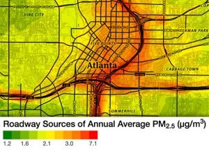 The results confirm what we suspected: air quality is generally worse in and around highly congested roads and freeways.
Click image to launch interactive map
Q: What’s PM2.5, and why is it potentially harmful?
A: PM2.5 is the scientific term for tiny bits of particles in the air, such as soot, dirt, dust and smoke. Manmade PM2.5 sources include car and truck exhaust and burning fuel at power plants or during industrial processes. These microscopic particles can lodge deep in the lungs, potentially causing health problems like asthma and cardiovascular conditions. Older adults and children are most at risk.
Q: How do you envision this study being used?
A: ARC used this model to develop our long-range plan, the Atlanta Region’s Plan, which was adopted in February. We were able to prioritize funding for transportation-related projects that will ease congestion in areas with poor air quality.
We also envision this tool helping local governments and school systems make decisions about where to locate sensitive facilities like playgrounds, trails, parks, and other places where the most vulnerable to air pollution spend more time outside
Q: What’s being done to improve air quality in the region?
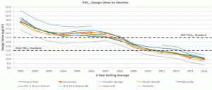 A: The good news is our air quality is improving. Since 2000, average annual PM2.5 concentrations have dropped nearly in half. We are meeting all federal air quality protection standards for fine particulate matter, even as the standards are toughened over time. We’ve also seen improvements in summertime ozone concentrations.
Factors that have helped clean our air include improved vehicle fuel economy, cleaner burning fuels, better pollution controls on power plants and increasing use of natural gas in power plants instead of coal.
And going forward, it’s important to get more people to walk, bike, carpool and take transit — steps that will reduce the number of tailpipes on our roadways.