Protecting the Chattahoochee River in Metro Atlanta
The Chattahoochee River is the largest river in metro Atlanta and one of the region’s most valuable resources, serving as the primary source of drinking water for millions of residents.
In 1972, the Atlanta Regional Commission completed the Chattahoochee Corridor Study in an attempt to quell a growing battle over the future of the Chattahoochee River in the Atlanta region. The study aimed to create a balanced, comprehensive plan for the future of the region’s most essential natural resource.
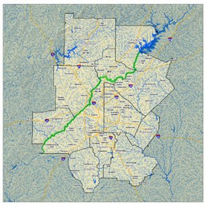
Chattahoochee River Corridor
The following year, the Georgia General Assembly adopted the Metropolitan River Protection Act (MRPA), which protected a 48-mile stretch of the Chattahoochee River between Buford Dam and Peachtree Creek by creating a 2,000 foot buffer along both banks of the river and its impoundments. The Act was amended in 1998 to extend the Corridor an additional 36 miles to the downstream limits of Fulton and Douglas counties. MRPA is codified in O.C.G.A. 12-5-440 et seq.
An interactive map of the Corridor has been developed to provide preliminary information on whether a given property may be located in the 2000-ft Chattahoochee River Corridor. Properties in this corridor are subject to development standards that may limit new land-disturbing activities. For more information, please contact the applicable local government’s planning department and the ARC, which administers the regional Chattahoochee Corridor Plan requirements.
MRPA is designed to protect the water quality and environs of the Chattahoochee River for use as:
One of the southern-most trout streams in the United States (and one of the very few located in a major metropolitan area)
Chattahoochee Corridor Plan
NOTICE: The Atlanta Regional Commission is proposing to amend the Chattahoochee Corridor Plan. The proposed amended document can be found here. The amended language starts on Page 5 of the document. The vote on the amendments by the ARC Board is scheduled for November 8, 2023.
Under MRPA, land-disturbing activity in the Chattahoochee corridor must comply with the adopted plan to be legal. Local governments in the corridor are required to:
Issue permits based on ARC findings
Monitor land-disturbing activity in the corridor
Ensure that land-disturbing activity in the corridor complies with the plan
Chattahoochee Corridor Plan Goals
Preservation and protection of water quality as a principal objective.
Protection of recreational values. These values include scenic views, historic and other unique areas, and controlled public access and use.
Protection of private property rights of landowners.
Prevention of activities that contribute to floods and flood damage.
Control of erosion and siltation.
Control of intensity of development.
Location and design of land uses in such a way as to minimize the adverse impact of urban development on the Chattahoochee River (the “River”) and flood plains.
Chattahoochee Corridor Plan Summary
The plan establishes three sets of development standards that must be met in order to reduce the impact of development on the river.
Vulnerability Standards:
Based on the characteristics of the land, all land in the corridor fits one of six vulnerability categories.
For each vulnerability category, there is a maximum percentage of allowable land disturbance and impervious surface.
Land disturbance includes any activity that disturbs the land or existing vegetation.
Impervious surface includes any paved, hardened or structural surface, regardless of material, and includes buildings, driveways, decks, patios, pools, etc.
Buffer Zone Standards:
50-foot undisturbed vegetative buffer along the river and its impoundments
35-foot undisturbed vegetative buffer along flowing streams in the corridor
150-foot impervious surface setback along the river and its impoundments
Floodplain Standards:
Balancing fill with an equal volume of cut in the river’s 100-year floodplain
No blocking of flood flows
35-foot height limit above existing grade for all structures except bridges in the river’s 500-year floodplain
MRPA Reviews
All land-disturbing activity in the corridor must be reviewed, approved and certified for consistency with Corridor Plan standards. ARC has adopted MRPA Rules and Regulations that explain the procedures and requirements for corridor reviews.
Review Procedures
Begin by contacting your local government to determine if a review is needed:
A review is required when a proposal increases the amount of land disturbance or impervious surface over existing or approved amounts.
A review might not be needed if the proposal does not increase existing land disturbance and impervious surface and does not affect other standards or, if the property has been reviewed previously, in which case development is allowed up to the approved limits.
When a review is required:
The applicant must fill out the Metropolitan River Protection Act Certificate Application and submit it, along with all required supporting material, to the relevant local government. The required supporting documents are listed on the application and in ARC’s Metropolitan River Protection Act Rules and Regulations.
The local government must forward the completed application to ARC for review. ARC reviews the application to determine if it is consistent with plan standards.
ARC completes the review and returns its finding to the local government.
The local government issues a certification based on ARC’s finding, which either authorizes or denies the proposed activity.
Local Government Responsibility
After a project has been certified, the local government will monitor its development for conformance to the approved review.
Local governments are also responsible for monitoring their corridor land for land-disturbing activity that has not been reviewed or authorized.
Any activity that violates the terms of an approved certificate or that occurs without certification is a violation of the Act. The local government has the authority and responsibility to enforce the law and take action against violators.
Contact and Review Materials
Contact Information
To determine if proposed activities within the Corridor require review, contact your local government’s planning department or contact ARC at 404.463.3100.